Skip to content

CCS Geo

GIS and Geographic Analysis

Using Sentinel Imagery to Analyze Drummond Co’s Coal Mining Operation in Colombia
ArcGIS Pro Esri Satellite Imagery Workflow

Using Sentinel Imagery to Analyze Drummond Co’s Coal Mining Operation in Colombia

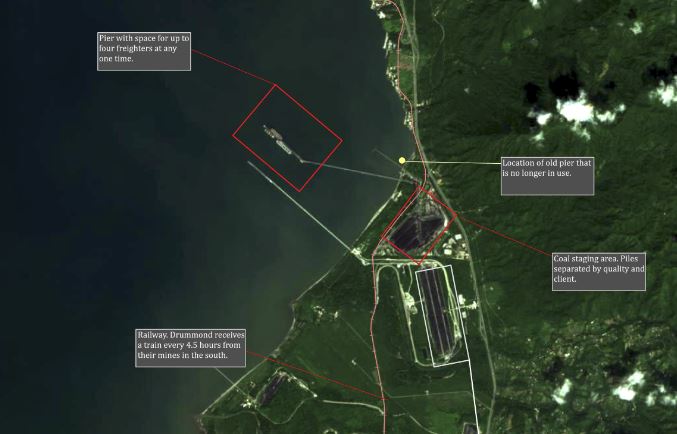
In a recent trip to Colombia, I had the opportunity to tour Puerto Drummond in Santa Marta. The port receives…

Carson SDecember 15, 2023December 15, 2023
Enabling HTTPS on WordPress Site Created in Linode
Technology Web

Enabling HTTPS on WordPress Site Created in Linode

During the creation of this blog I had some trouble deciphering how to enable https. I initially created the site…

Carson SDecember 5, 2023December 7, 2023
The Cost of Satellite Imagery for Independent Analysis
General Satellite Imagery

The Cost of Satellite Imagery for Independent Analysis

I have always wondered about the cost of high-resolution satellite imagery. We see satellite imagery being used more and more…

Carson SDecember 3, 2023December 15, 2023
Hello Globe!
General

Hello Globe!

I am excited to announce the launch of my GIS and Geography blog! I am interested in sharing cool datasets,…

Carson SNovember 30, 2023December 18, 2023

Posts navigation

Newer posts

About Me

My name is Carson and I am a GIS professional interested in sharing all things GIS and Geography. I currently work for Esri Canada as an Enterprise Support Consultant with a focus on Enterprise Geodatabases.

Contact

Need a map made? Just want to chat GIS? Send me an email:

admin@ccsgeo.com

Or check out my LinkedIn:

https://www.linkedin.com/in/carson-smulders/

Recent Posts

  • The ‘Sub-Orbital’ launch of Launchmap.net
  • Deploying an Open Source GIS Stack (Part 3.5: Publishing Layers to Geoserver)
  • Open Data Discovery: Great Lakes Aquatic Habitat Framework
  • Deploying an Open Source GIS Stack (Part 3: Installing Geoserver)
  • Geospatial Book Review: The Deepest Map

Archives

  • March 2025
  • March 2024
  • January 2024
  • December 2023
  • November 2023

Categories

  • ArcGIS Pro
  • Coding
  • Esri
  • FOSS
  • General
  • Geographic Thinking
  • Geography
  • Mapping
  • Oceans
  • Open Data Discovery
  • QGIS
  • Satellite Imagery
  • Space
  • Technology
  • Web
  • Workflow

Copyright © 2025 CCS Geo | Marvel Blog by Ascendoor | Powered by WordPress.